Geolocate

Navotas topographic map

Click on the map to display elevation.

About this map

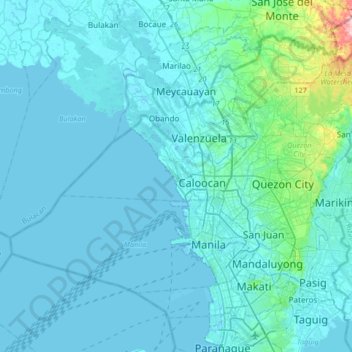
Name: Navotas topographic map, elevation, terrain.

Location: Navotas, Metro Manila, 1485, Philippines (14.49698 120.78780 14.81698 121.10780)

Average elevation: 16 m

Minimum elevation: -3 m

Maximum elevation: 215 m

Other topographic maps

Click on a map to view its topography, its elevation and its terrain.

Navotas River

Philippines > Navotas

Average elevation: 5 m

Navotas City Park

Philippines > Navotas

Average elevation: 4 m

Tanza

Philippines > Navotas

Average elevation: 2 m

Tangos River

Philippines > Navotas

Average elevation: 3 m

Gear up for your next adventure:

Backpacking Tent - Lightweight tent for long-distance hiking trips
🧭GPS Tracker - Track your location in remote areas safely
🧊Portable Cooler - Keep food and drinks cold during outdoor adventures
🥾Durable Hiking Shoes - Long-lasting shoes for frequent hiking
🛌Down Sleeping Bag - Superior warmth-to-weight ratio for cold nights

As an Amazon Associate, this site earns from qualifying purchases at no extra cost to you.