Geolocate

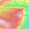
Colle du Comte topographic map

Click on the map to display elevation.

About this map

Name: Colle du Comte topographic map, elevation, terrain.

Location: Colle du Comte, Mons, Draguignan, Var, Provence-Alpes-Côte d'Azur, France métropolitaine, 83440, France (43.63840 6.69673 43.67840 6.73673)

Average elevation: 523 m

Minimum elevation: 329 m

Maximum elevation: 766 m

Other topographic maps

Click on a map to view its topography, its elevation and its terrain.
Village

France > Provence-Alpes-Côte d'Azur > Var > Mons

Average elevation: 769 m

Gear up for your next adventure:

⛺Lightweight Backpacking Tent - Compact tent for efficient hiking trips
🚑Survival Whistle - Signal for help across long distances in mountains
🥾All-Terrain Hiking Boots - Versatile boots for varied hiking conditions
🥤Collapsible Travel Cup - Saves space and weight in your mess kit
🛰️Satellite Messenger - Emergency communication for areas with no cell service

As an Amazon Associate, this site earns from qualifying purchases at no extra cost to you.