Geolocate

Trousa topographic map

Click on the map to display elevation.

About this map

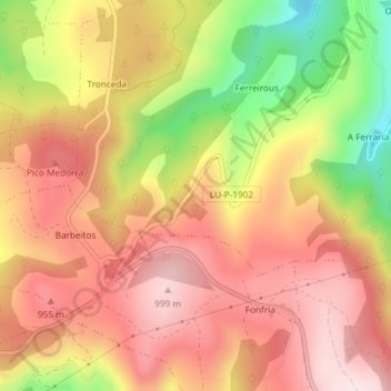
Name: Trousa topographic map, elevation, terrain.

Location: Trousa, A Allonca, Fonsagrada, Lugo, Galicia, 27118, España (43.14632 -7.01813 43.16632 -6.99813)

Average elevation: 849 m

Minimum elevation: 603 m

Maximum elevation: 1,005 m

Other topographic maps

Click on a map to view its topography, its elevation and its terrain.

Carballido

España > Galicia > Fonsagrada > Fonsagrada

Average elevation: 648 m

Gear up for your next adventure:

🧥Thermal Fleece Jacket - Versatile insulation for changing mountain temperatures
🧼Travel Hand Sanitizer - Keep hands clean when water is scarce
🧤Insulated Winter Gloves - Heavy-duty protection for sub-zero Canadian adventures
💧Collapsible Water Bottle - Space-saving water bottle for outdoor activities
🧴Waterproofing Spray - Restore the DWR coating on jackets and tents

As an Amazon Associate, this site earns from qualifying purchases at no extra cost to you.