Geolocate

Beaujeu topographic map

Click on the map to display elevation.

About this map

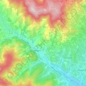
Name: Beaujeu topographic map, elevation, terrain.

Location: Beaujeu, Villefranche-sur-Saône, Rhône, Auvergne-Rhône-Alpes, Metropolitan France, 69430, France (46.12641 4.54684 46.19047 4.61337)

Average elevation: 497 m

Minimum elevation: 243 m

Maximum elevation: 883 m

Other topographic maps

Click on a map to view its topography, its elevation and its terrain.

Le Bourg

France > Auvergne-Rhône-Alpes > Rhône > Juliénas

Average elevation: 316 m

Fondrieu

France > Auvergne-Rhône-Alpes > Rhône > Rontalon

Average elevation: 493 m

La Roche

France > Auvergne-Rhône-Alpes > Rhône > Ampuis

Average elevation: 243 m

Maladière

France > Auvergne-Rhône-Alpes > Rhône > Condrieu

Average elevation: 237 m

Gear up for your next adventure:

🧥Ultralight Puffy Jacket - Maximum warmth that packs down to the size of an orange
🧴Waterproofing Spray - Restore the DWR coating on jackets and tents
🥾Hiking Leggings - Comfortable leggings for outdoor activities
🥾Trail Hiking Shoes - Durable shoes designed for rugged trails
🧤Insulated Winter Gloves - Heavy-duty protection for sub-zero Canadian adventures

As an Amazon Associate, this site earns from qualifying purchases at no extra cost to you.