Geolocate

Doranda topographic map

Click on the map to display elevation.

About this map

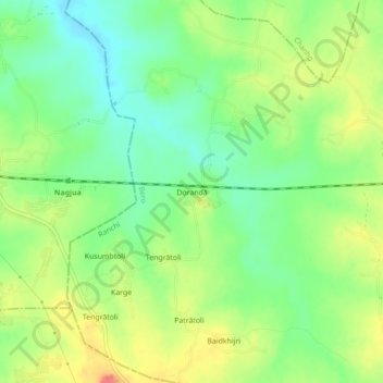
Name: Doranda topographic map, elevation, terrain.

Location: Doranda, Bero, Ranchi, Jharkhand, 835325, India (23.36419 84.87991 23.40419 84.91991)

Average elevation: 695 m

Minimum elevation: 668 m

Maximum elevation: 731 m

Gear up for your next adventure:

🥾Lightweight Hiking Boots - Boots for comfort and mobility on long hikes
🔭Compact Monocular - One-handed bird watching and trail spotting
🧼Biodegradable Camp Soap - Environmentally friendly cleaning for gear and body
🧳Compression Sacks - Maximize space in your backpack by shrinking gear
🧦Merino Wool Socks - Moisture-wicking comfort for long-distance hiking

As an Amazon Associate, this site earns from qualifying purchases at no extra cost to you.