
Make a donation
Gear up for your next adventure:
As an Amazon Associate, this site earns from qualifying purchases at no extra cost to you.
Ulverston topographic map
Click on the map to display elevation.
Make a donation
Gear up for your next adventure:
As an Amazon Associate, this site earns from qualifying purchases at no extra cost to you.
About this map
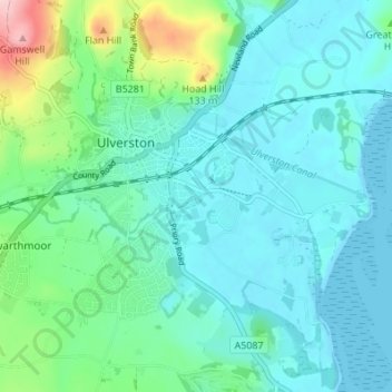
Name: Ulverston topographic map, elevation, terrain.
Location: Ulverston, Westmorland and Furness, England, United Kingdom (54.17084 -3.11919 54.21008 -3.05087)
Average elevation: 38 m
Minimum elevation: -1 m
Maximum elevation: 201 m
Make a donation
Gear up for your next adventure:
As an Amazon Associate, this site earns from qualifying purchases at no extra cost to you.
Other topographic maps
Click on a map to view its topography, its elevation and its terrain.
Pennines
United Kingdom > England > Westmorland and Furness
According to the Köppen classification, the Pennines generally have a temperate oceanic climate (Cfb) like the rest of England, but the uplands have more precipitation, stronger winds and colder weather than the surrounding areas. Some of the higher elevations have a subpolar oceanic climate (Cfc), which may…
Average elevation: 761 m
Alston
United Kingdom > England > Westmorland and Furness
Alston is a town in Westmorland and Furness, Cumbria, England, within the civil parish of Alston Moor on the River South Tyne. It shares the title of the 'highest market town in England', at about 1,000 feet (300 m) above sea level, with Buxton, Derbyshire. Despite its altitude, the town is easily accessible…
Average elevation: 404 m