
Copiapó topographic map
Interactive map
Click on the map to display elevation.
About this map
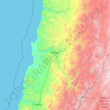
Name: Copiapó topographic map, elevation, terrain.
Location: Copiapó, Provincia de Copiapó, Atacama Region, Chile (-28.18339 -71.14235 -26.66433 -68.26321)
Average elevation: 1,659 m
Minimum elevation: 0 m
Maximum elevation: 6,289 m
Other topographic maps
Click on a map to view its topography, its elevation and its terrain.
Laguna Verde
Chile > Atacama Region > Provincia de Copiapó > Copiapó
Laguna Verde, Copiapó, Provincia de Copiapó, Atacama Region, Chile
Average elevation: 4,384 m