
Make a donation
Gear up for your next adventure:
As an Amazon Associate, this site earns from qualifying purchases at no extra cost to you.
Mudersbach topographic map
Click on the map to display elevation.
Make a donation
Gear up for your next adventure:
As an Amazon Associate, this site earns from qualifying purchases at no extra cost to you.
About this map
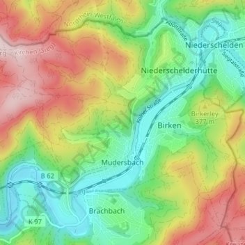
Name: Mudersbach topographic map, elevation, terrain.
Average elevation: 328 m
Minimum elevation: 199 m
Maximum elevation: 517 m
Make a donation
Gear up for your next adventure:
As an Amazon Associate, this site earns from qualifying purchases at no extra cost to you.
Other topographic maps
Click on a map to view its topography, its elevation and its terrain.
Altenkirchen
Deutschland > Rheinland-Pfalz > Landkreis Altenkirchen (Westerwald) > Altenkirchen (Westerwald)
Der Umzug der Karnevalsgesellschaft Altenkirchen 1972 e. V. am Karnevalssonntag, die Maifete am ersten Maiwochenende, das traditionelle Schützenfest der Altenkirchener Schützengesellschaft 1845 e. V. Anfang Juli oder das Oktoberfest gehören zu den Höhepunkten des Jahres.
Average elevation: 276 m