
Make a donation
Gear up for your next adventure:
As an Amazon Associate, this site earns from qualifying purchases at no extra cost to you.
Gennep topographic map
Click on the map to display elevation.
Make a donation
Gear up for your next adventure:
As an Amazon Associate, this site earns from qualifying purchases at no extra cost to you.
Gennep
Gennep ligt op de rechteroever van de Maas, op een hoogte van ongeveer 12 meter. De kom van Gennep wordt aan de noordzijde begrensd door de Niers. Deze vormt naar de monding toe een schiereiland met op de uiterste punt de ruïnes van het Genneperhuis. Ten zuiden van Gennep ligt de Sint Augustinusstichting, een instelling ten behoeve van verstandelijk gehandicapten. Aansluitend vindt men het Heijense Bos en landgoed Het Huis Heijen op het grondgebied van Heijen. In het oosten vindt men de Genneperheide, een natuurgebied. Daarop aansluitend ligt de inrichting Maria Roepaan op het grondgebied van Ottersum. Sinds 2000 nestelt een paartje ooievaars op het oude stadhuis van Gennep. Sinds 2015 zijn ze gratis live te volgen op de webcam van de Vogelbescherming ('Beleef de lente').
Make a donation
Gear up for your next adventure:
As an Amazon Associate, this site earns from qualifying purchases at no extra cost to you.
About this map
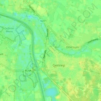
Name: Gennep topographic map, elevation, terrain.
Location: Gennep, Limburg, Nederland (51.68038 5.94672 51.72190 6.00390)
Average elevation: 13 m
Minimum elevation: 4 m
Maximum elevation: 19 m
Make a donation
Gear up for your next adventure:
As an Amazon Associate, this site earns from qualifying purchases at no extra cost to you.
Other topographic maps
Click on a map to view its topography, its elevation and its terrain.