
Make a donation
Gear up for your next adventure:
As an Amazon Associate, this site earns from qualifying purchases at no extra cost to you.
Hemeln topographic map
Click on the map to display elevation.
Make a donation
Gear up for your next adventure:
As an Amazon Associate, this site earns from qualifying purchases at no extra cost to you.
Hemeln
Ursprünglich in der Hemelner Feldmark gelegen, wurde der Scheibenkreuzstein anschließend an den östlichen Rand der Weserstraße verlegt, wo er sich heute in Höhe eines Wanderparkplatzes befindet. Er trägt auf der Vorder- und Rückseite zwei gleichartige Malteserkreuze, von denen eines witterungsbedingt verwaschen und leicht beschädigt ist. Oberhalb der Kreuze sind Wetzspuren zu sehen. Überlieferungen zu diesem Stein sind nicht bekannt.
Make a donation
Gear up for your next adventure:
As an Amazon Associate, this site earns from qualifying purchases at no extra cost to you.
About this map
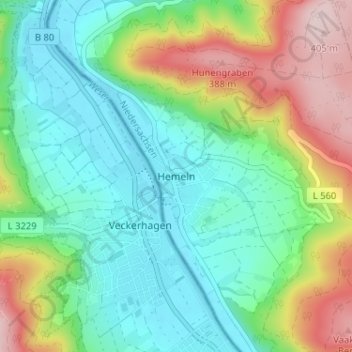
Name: Hemeln topographic map, elevation, terrain.
Average elevation: 207 m
Minimum elevation: 111 m
Maximum elevation: 413 m
Make a donation
Gear up for your next adventure:
As an Amazon Associate, this site earns from qualifying purchases at no extra cost to you.
Other topographic maps
Click on a map to view its topography, its elevation and its terrain.
Forstbotanischer Garten
Deutschland > Niedersachsen > Landkreis Göttingen > Hann. Münden
Average elevation: 182 m
34346
Deutschland > Niedersachsen > Landkreis Göttingen > Hann. Münden > Volkmarshausen
Average elevation: 286 m