Geolocate

Bellevue topographic map

Click on the map to display elevation.

About this map

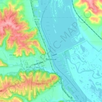
Name: Bellevue topographic map, elevation, terrain.

Location: Bellevue, Jackson County, Iowa, 52031, United States (42.23262 -90.44770 42.29461 -90.40671)

Average elevation: 208 m

Minimum elevation: 177 m

Maximum elevation: 295 m

Other topographic maps

Click on a map to view its topography, its elevation and its terrain.

Fulton

United States > Iowa > Jackson County

Average elevation: 231 m

Ozark

United States > Iowa > Jackson County

Average elevation: 266 m

Ozark

United States > Iowa > Jackson County

Average elevation: 266 m

Ozark

United States > Iowa > Jackson County

Average elevation: 266 m

Gear up for your next adventure:

🧴First Aid Kit - Essential first aid supplies for outdoor emergencies
🌡️Emergency Mylar Blankets - Compact thermal protection for unexpected nights outdoors
🧤Insulated Winter Gloves - Heavy-duty protection for sub-zero Canadian adventures
🥾Hiking Shorts - Breathable shorts suitable for summer hikes
🔨Vehicle Emergency Tool - Safety tool for remote road trips to trailheads

As an Amazon Associate, this site earns from qualifying purchases at no extra cost to you.