Geolocate

La Cantine topographic map

Click on the map to display elevation.

About this map

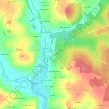
Name: La Cantine topographic map, elevation, terrain.

Location: La Cantine, Les Forges, Forges-de-Lanouée, Pontivy, Morbihan, Bretagne, France métropolitaine, 56120, France (47.99904 -2.66669 48.03904 -2.62669)

Average elevation: 79 m

Minimum elevation: 41 m

Maximum elevation: 121 m

Other topographic maps

Click on a map to view its topography, its elevation and its terrain.

Les Forges

France > Bretagne > Morbihan > Forges-de-Lanouée

Le relief est assez bosselé, culminant à 123 mètres, le long de la "ligne du Télégraphe", dans la partie nord de la forêt de Lanouée, laquelle est presque partout au-dessus de 90 mètres d'altitude, et s'abaissant dans les vallées des cours d'eau précités, le point le plus bas étant à 43 mètres…

Average elevation: 90 m

Lanouée

France > Bretagne > Morbihan > Forges-de-Lanouée

Average elevation: 86 m

Gear up for your next adventure:

🔨Vehicle Emergency Tool - Safety tool for remote road trips to trailheads
🥾Trail Running Shoes - Lightweight and durable shoes for trail running
🧼Biodegradable Camp Soap - Environmentally friendly cleaning for gear and body
🥽Outdoor Goggles - Protective eyewear for outdoor activities
🧰Multitool Knife - Compact and versatile tool for outdoor use

As an Amazon Associate, this site earns from qualifying purchases at no extra cost to you.