Geolocate

Phek topographic map

Click on the map to display elevation.

About this map

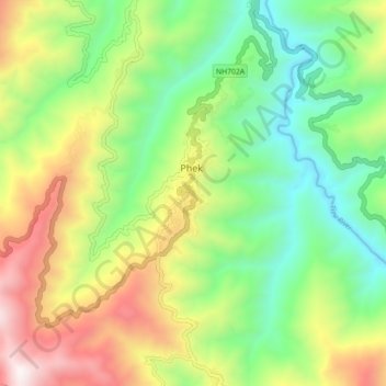
Name: Phek topographic map, elevation, terrain.

Location: Phek, Phek Sadar, Phek, Nagaland, 797108, India (25.66983 94.42334 25.74983 94.50334)

Average elevation: 1,233 m

Minimum elevation: 667 m

Maximum elevation: 2,144 m

Gear up for your next adventure:

🧢Outdoor Cap - Protective cap for sun and rain during hikes
🎒Hiking Daypack - Lightweight and durable backpacks for day trips and excursions
🧰Emergency Multi-Tool - Compact multi-tool for outdoor survival
🦯Trekking Poles - Reduced impact on joints for steep topographic climbs
🧊Portable Cooler - Keep food and drinks cold during outdoor adventures

As an Amazon Associate, this site earns from qualifying purchases at no extra cost to you.