
Make a donation
Gear up for your next adventure:
As an Amazon Associate, this site earns from qualifying purchases at no extra cost to you.
Napremont topographic map
Click on the map to display elevation.
Make a donation
Gear up for your next adventure:
As an Amazon Associate, this site earns from qualifying purchases at no extra cost to you.
About this map
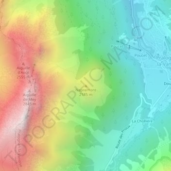
Name: Napremont topographic map, elevation, terrain.
Average elevation: 1,945 m
Minimum elevation: 1,373 m
Maximum elevation: 2,864 m
Make a donation
Gear up for your next adventure:
As an Amazon Associate, this site earns from qualifying purchases at no extra cost to you.
Other topographic maps
Click on a map to view its topography, its elevation and its terrain.
Lac des Vaches
France > Auvergne-Rhône-Alpes > Savoie > Pralognan-la-Vanoise
Average elevation: 2,510 m
Glacier du Génépy
France > Auvergne-Rhône-Alpes > Savoie > Pralognan-la-Vanoise
Average elevation: 3,088 m
Glacier de la Grande Casse
France > Auvergne-Rhône-Alpes > Savoie > Pralognan-la-Vanoise
Average elevation: 2,896 m
Glacier de la Grande Casse
France > Auvergne-Rhône-Alpes > Savoie > Pralognan-la-Vanoise
Average elevation: 2,896 m
Make a donation
Gear up for your next adventure:
As an Amazon Associate, this site earns from qualifying purchases at no extra cost to you.