
Thank you for supporting this site ❤️
Make a donation
Make a donation
Gear up for your next adventure:
As an Amazon Associate, this site earns from qualifying purchases at no extra cost to you.
Köttingen topographic map
Click on the map to display elevation.
Thank you for supporting this site ❤️
Make a donation
Make a donation
Gear up for your next adventure:
As an Amazon Associate, this site earns from qualifying purchases at no extra cost to you.
Köttingen
Köttingen liegt südwestlich von Lindlar, zwischen Schmitzhöhe und Hohkeppel im Lennefetal. Der Lennefer Bach durchfließt den Ort. Beim Ort findet sich eine stillgelegte Kläranlage. Seit 2012 ist VDSL verfügbar.
Thank you for supporting this site ❤️
Make a donation
Make a donation
Gear up for your next adventure:
As an Amazon Associate, this site earns from qualifying purchases at no extra cost to you.
About this map
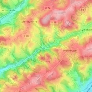
Name: Köttingen topographic map, elevation, terrain.
Average elevation: 196 m
Minimum elevation: 100 m
Maximum elevation: 268 m
Thank you for supporting this site ❤️
Make a donation
Make a donation
Gear up for your next adventure:
As an Amazon Associate, this site earns from qualifying purchases at no extra cost to you.