Geolocate

Sheboygan topographic map

Click on the map to display elevation.

About this map

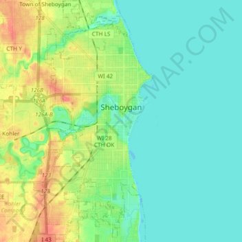
Name: Sheboygan topographic map, elevation, terrain.

Location: Sheboygan, Sheboygan County, Wisconsin, 53081, United States (43.69124 -87.76543 43.79762 -87.69553)

Average elevation: 188 m

Minimum elevation: 172 m

Maximum elevation: 228 m

Gear up for your next adventure:

🔦LED Headtorch - Bright and durable light for night activities
🧥Packable Rain Jacket - Breathable waterproof layer for unpredictable weather
🧢Sun Hat - Wide-brim hat for sun protection
🧦Hiking Socks - Moisture-wicking and comfortable socks for long hikes
🧢Hiking Sun Hat - Wide-brimmed protection for exposed mountain ridges

As an Amazon Associate, this site earns from qualifying purchases at no extra cost to you.