
Kassel topographic map
Interactive map
Click on the map to display elevation.
About this map
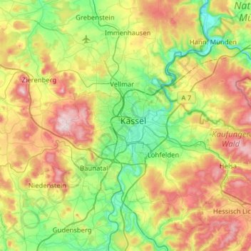
Name: Kassel topographic map, elevation, terrain.
Location: Kassel, Hessen, 34117, Deutschland (51.15545 9.33241 51.47545 9.65241)
Average elevation: 296 m
Minimum elevation: 113 m
Maximum elevation: 620 m
Other topographic maps
Click on a map to view its topography, its elevation and its terrain.
Fasanenhof
Deutschland > Hessen > Kassel
Fasanenhof, Kassel, Regierungsbezirk Kassel, Hessen, Deutschland
Average elevation: 175 m