Geolocate

Kolar topographic map

Click on the map to display elevation.

About this map

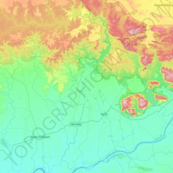
Name: Kolar topographic map, elevation, terrain.

Location: Kolar, Ichhawar Tahsil, Sehore, Madhya Pradesh, 466115, India (22.59596 77.06719 23.00813 77.45090)

Average elevation: 376 m

Minimum elevation: 268 m

Maximum elevation: 661 m

Gear up for your next adventure:

🥾Trail Running Boots - Durable shoes designed for trail running
🧥Packable Rain Jacket - Breathable waterproof layer for unpredictable weather
🥾Approach Shoes - Shoes designed for climbing approaches and rugged trails
🧥Softshell Jacket - Windproof and breathable jacket for hiking
🔭Compact Monocular - One-handed bird watching and trail spotting

As an Amazon Associate, this site earns from qualifying purchases at no extra cost to you.