Geolocate

Troy topographic map

Click on the map to display elevation.

About this map

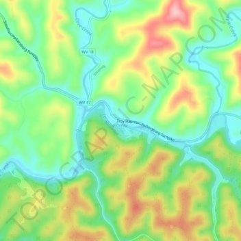
Name: Troy topographic map, elevation, terrain.

Location: Troy, Gilmer County, West Virginia, United States (38.99981 -80.78316 39.03981 -80.74316)

Average elevation: 286 m

Minimum elevation: 216 m

Maximum elevation: 394 m

Other topographic maps

Click on a map to view its topography, its elevation and its terrain.

Glenville

United States > West Virginia > Gilmer County

Average elevation: 280 m

Glenville

United States > West Virginia > Gilmer County

Average elevation: 280 m

Gear up for your next adventure:

🧢Outdoor Cap - Protective cap for sun and rain during hikes
Family Camping Tent - Spacious tent suitable for family camping trips
🦌Outdoor Trail Camera - Monitor wildlife activity near your favorite spots
🥾Hiking Boots - Sturdy boots providing ankle support and traction on rugged trails
🛏️Camping Sleeping Mat - Comfortable mats for sleeping outdoors

As an Amazon Associate, this site earns from qualifying purchases at no extra cost to you.