Geolocate

charlevila topographic map

Click on the map to display elevation.

About this map

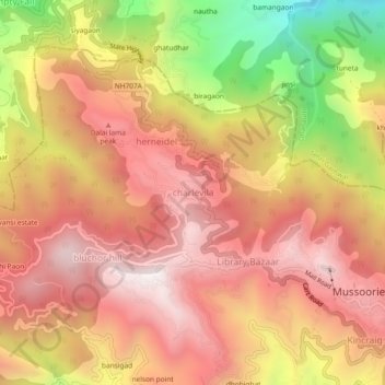
Name: charlevila topographic map, elevation, terrain.

Location: charlevila, Dehradun, Uttarakhand, 248179, India (30.44721 78.03831 30.48721 78.07831)

Average elevation: 1,741 m

Minimum elevation: 1,015 m

Maximum elevation: 2,177 m

Gear up for your next adventure:

🔋Lithium AA Batteries - Long-lasting power that performs in extreme cold
🛶Kayak Accessories - Essential gear for safe and fun kayaking adventures
🕶️Polarized Sunglasses - Protect your eyes with durable polarized lenses
Camping Tent - Weather-resistant tents suitable for 2 to 6 people
🧢Beanie Hat - Keep your head warm in cold weather

As an Amazon Associate, this site earns from qualifying purchases at no extra cost to you.