
Make a donation
Gear up for your next adventure:
As an Amazon Associate, this site earns from qualifying purchases at no extra cost to you.
Gravellona Toce topographic map
Click on the map to display elevation.
Make a donation
Gear up for your next adventure:
As an Amazon Associate, this site earns from qualifying purchases at no extra cost to you.
Gravellona Toce
Der Ort liegt 11 km von der Provinzhauptstadt Verbania entfernt auf einer Höhe von 211 m ü. M. Das Gemeindegebiet umfasst eine Fläche von 14,67 km². Gravellona Toce gilt, ähnlich wie Omegna, als typisches Beispiel einer großflächigen Zersiedelung nördlich von Mailand. Gravellona Toce und Omegna sind mittlerweile zusammengewachsen, obwohl die jeweiligen Ortszentren sieben Kilometer voneinander entfernt liegen. Auch in östlicher Richtung erstrecken sich Industriebetriebe in Richtung Lago Maggiore. Die Nachbargemeinden sind Baveno, Casale Corte Cerro, Mergozzo, Omegna, Ornavasso, Stresa und Verbania. Der Schutzheilige des Ortes ist San Pietro.
Make a donation
Gear up for your next adventure:
As an Amazon Associate, this site earns from qualifying purchases at no extra cost to you.
About this map
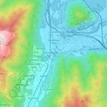
Name: Gravellona Toce topographic map, elevation, terrain.
Location: Gravellona Toce, Verbano-Cusio-Ossola, Piemont, 28883, Italien (45.89086 8.40351 45.95505 8.46008)
Average elevation: 567 m
Minimum elevation: 189 m
Maximum elevation: 1,687 m
Make a donation
Gear up for your next adventure:
As an Amazon Associate, this site earns from qualifying purchases at no extra cost to you.