Geolocate

Vidin topographic map

Click on the map to display elevation.

About this map

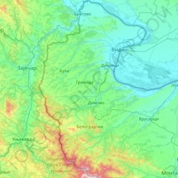
Name: Vidin topographic map, elevation, terrain.

Location: Vidin, Bulgaria (43.38662 22.35715 44.21565 23.05842)

Average elevation: 305 m

Minimum elevation: 24 m

Maximum elevation: 2,153 m

Other topographic maps

Click on a map to view its topography, its elevation and its terrain.

Levski

Bulgaria > Levski

Average elevation: 76 m

Svilengrad

Bulgaria > Svilengrad

Average elevation: 79 m

Pleven

Bulgaria > Pleven

Average elevation: 190 m

Kutovo

Bulgaria > Vidin > Vidin

Average elevation: 39 m

Gear up for your next adventure:

🧣Merino Neck Gaiter - Protects against wind, sun, and cold at high altitudes
🧦Crew Hiking Socks - Comfortable socks for long-distance hikes
💡Compact LED Flashlight - Powerful and portable flashlight for outdoor use
🥾Hiking Shorts - Breathable shorts suitable for summer hikes
🔥Emergency Fire Starter - Reliable ignition source for all weather conditions

As an Amazon Associate, this site earns from qualifying purchases at no extra cost to you.