
Negaunee topographic map
Click on the map to display elevation.
About this map
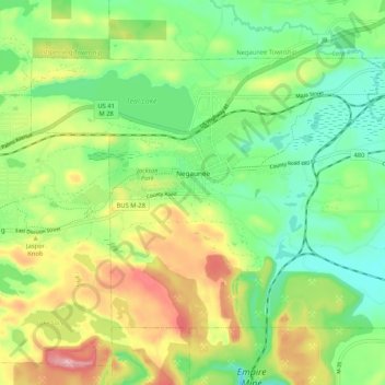
Name: Negaunee topographic map, elevation, terrain.
Location: Negaunee, Marquette County, Michigan, 49866, United States (46.47017 -87.65586 46.52075 -87.55137)
Average elevation: 441 m
Minimum elevation: 364 m
Maximum elevation: 569 m
Other topographic maps
Click on a map to view its topography, its elevation and its terrain.
Van Riper State Park
United States > Michigan > Marquette County > Michigamme Township
Average elevation: 489 m
Skinnies Lake
United States > Michigan > Marquette County > Humboldt Township
Average elevation: 453 m
Horseshoe Lake
United States > Michigan > Marquette County > Republic Township
Average elevation: 503 m