
Thank you for supporting this site ❤️
Make a donation
Make a donation
Gear up for your next adventure:
As an Amazon Associate, this site earns from qualifying purchases at no extra cost to you.
Ulaankhus topographic map
Click on the map to display elevation.
Thank you for supporting this site ❤️
Make a donation
Make a donation
Gear up for your next adventure:
As an Amazon Associate, this site earns from qualifying purchases at no extra cost to you.
About this map
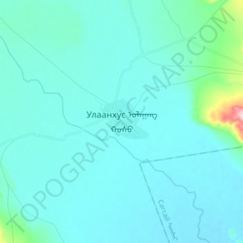
Name: Ulaankhus topographic map, elevation, terrain.
Location: Ulaankhus, Bayan-Ölgii, Mongolia (49.00137 89.39854 49.08137 89.47854)
Average elevation: 1,787 m
Minimum elevation: 1,762 m
Maximum elevation: 2,041 m
Thank you for supporting this site ❤️
Make a donation
Make a donation
Gear up for your next adventure:
As an Amazon Associate, this site earns from qualifying purchases at no extra cost to you.