
Thank you for supporting this site ❤️
Make a donation
Make a donation
Gear up for your next adventure:
As an Amazon Associate, this site earns from qualifying purchases at no extra cost to you.
Povorais topographic map
Click on the map to display elevation.
Thank you for supporting this site ❤️
Make a donation
Make a donation
Gear up for your next adventure:
As an Amazon Associate, this site earns from qualifying purchases at no extra cost to you.
About this map
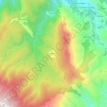
Name: Povorais topographic map, elevation, terrain.
Location: Povorais, Góis, Coimbra, 3750-048, Portugal (40.07587 -8.15383 40.11587 -8.11383)
Average elevation: 796 m
Minimum elevation: 472 m
Maximum elevation: 1,184 m
Thank you for supporting this site ❤️
Make a donation
Make a donation
Gear up for your next adventure:
As an Amazon Associate, this site earns from qualifying purchases at no extra cost to you.