
Thank you for supporting this site ❤️
Make a donation
Make a donation
Gear up for your next adventure:
As an Amazon Associate, this site earns from qualifying purchases at no extra cost to you.
Abergavenny topographic map
Click on the map to display elevation.
Thank you for supporting this site ❤️
Make a donation
Make a donation
Gear up for your next adventure:
As an Amazon Associate, this site earns from qualifying purchases at no extra cost to you.
About this map
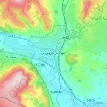
Name: Abergavenny topographic map, elevation, terrain.
Location: Abergavenny, Monmouthshire, Wales, NP7 5NQ, United Kingdom (51.78132 -3.05479 51.86132 -2.97479)
Average elevation: 187 m
Minimum elevation: 33 m
Maximum elevation: 554 m
Thank you for supporting this site ❤️
Make a donation
Make a donation
Gear up for your next adventure:
As an Amazon Associate, this site earns from qualifying purchases at no extra cost to you.