Geolocate

Chessore Village topographic map

Click on the map to display elevation.

About this map

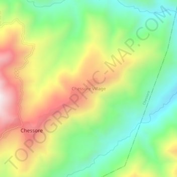
Name: Chessore Village topographic map, elevation, terrain.

Location: Chessore Village, Chessore, Tuensang, Nagaland, India (26.07182 94.72902 26.11182 94.76902)

Average elevation: 1,325 m

Minimum elevation: 920 m

Maximum elevation: 1,873 m

Gear up for your next adventure:

🥾Hiking Shoes - Durable and comfortable shoes for trail hiking
🩹Compact First Aid Kit - Pre-packed essentials for common trail injuries
🎒Hiking Daypack - Lightweight and durable backpacks for day trips and excursions
🎒Backpack Rain Cover - External shield to keep your entire pack dry
🧦Outdoor Socks - Durable socks designed for hiking and outdoor sports

As an Amazon Associate, this site earns from qualifying purchases at no extra cost to you.