
Make a donation
Gear up for your next adventure:
As an Amazon Associate, this site earns from qualifying purchases at no extra cost to you.
Bergstein topographic map
Click on the map to display elevation.
Make a donation
Gear up for your next adventure:
As an Amazon Associate, this site earns from qualifying purchases at no extra cost to you.
About this map
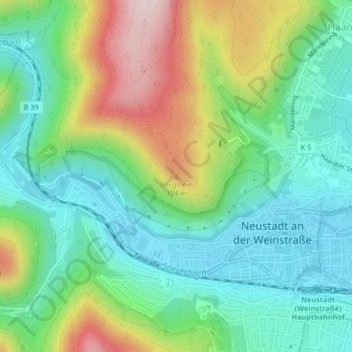
Name: Bergstein topographic map, elevation, terrain.
Average elevation: 254 m
Minimum elevation: 137 m
Maximum elevation: 494 m
Make a donation
Gear up for your next adventure:
As an Amazon Associate, this site earns from qualifying purchases at no extra cost to you.
Other topographic maps
Click on a map to view its topography, its elevation and its terrain.
Gimmeldingen
Deutschland > Rheinland-Pfalz > Neustadt an der Weinstraße
Der Ortskern gruppiert sich auf einer Höhe von 152 bis 230 m um die protestantische Pfarrkirche und das ehemalige Rathaus (jeweils 183 m) auf einem Hügel an der Deutschen Weinstraße in der Vorderpfalz am westlichen Rand der Oberrheinischen Tiefebene. In die südlich des Hügels gelegene Talaue des Mußbachs…
Average elevation: 285 m
Geinsheim
Deutschland > Rheinland-Pfalz > Neustadt an der Weinstraße
Stadtviertel: Afrikaviertel | Branchweiler | Hambacher Höhe | Schöntal | Winzingen
Average elevation: 116 m
Make a donation
Gear up for your next adventure:
As an Amazon Associate, this site earns from qualifying purchases at no extra cost to you.
Diedesfeld
Deutschland > Rheinland-Pfalz > Neustadt an der Weinstraße
Diedesfeld liegt am Mittelpunkt der 85 km langen Deutschen Weinstraße und an der Nordroute der Pfälzer Jakobswege. Außerdem ist der Ort Ausgangspunkt eines Wanderwegs, der mit einem blauen Punkt markiert ist. Westlich des Siedlungsgebiets liegt die Klausentalhütte sowie in 300 m Höhe das als Ausflugsziel…
Average elevation: 239 m