Geolocate

Khudi topographic map

Click on the map to display elevation.

About this map

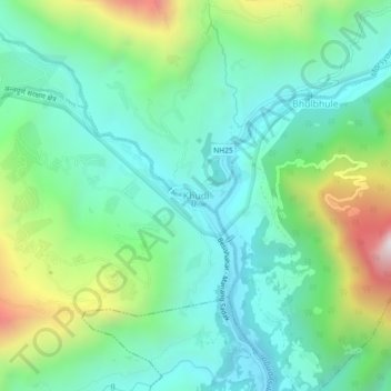
Name: Khudi topographic map, elevation, terrain.

Location: Khudi, Marsyangdi, Lamjung, Gandaki Province, 33600, Nepal (28.26098 84.33762 28.30098 84.37762)

Average elevation: 1,064 m

Minimum elevation: 744 m

Maximum elevation: 1,894 m

Gear up for your next adventure:

🧭Orienteering Kit - Tools for map reading and navigation in the wild
🥾Trail Hiking Shoes - Durable shoes designed for rugged trails
🧢Hiking Hat - Sun-protective and breathable hats for long treks
🧰Multitool Knife - Compact and versatile tool for outdoor use
🔥Camping Stove - Portable stoves to cook outdoors with ease

As an Amazon Associate, this site earns from qualifying purchases at no extra cost to you.