
Make a donation
Gear up for your next adventure:
As an Amazon Associate, this site earns from qualifying purchases at no extra cost to you.
Arquennes topographic map
Click on the map to display elevation.
Make a donation
Gear up for your next adventure:
As an Amazon Associate, this site earns from qualifying purchases at no extra cost to you.
Arquennes
Arquennes ligt aan de Samme die hier tevens de oude bedding van het Kanaal Charleroi-Brussel vormt. Bij Arquennes liggen enkele bossen zoals het Bois de l'Hôpital, Bois d'Arpes en Bois de Petit-Roeulx. De hoogte aan de kerk bedraagt 101 meter.
Make a donation
Gear up for your next adventure:
As an Amazon Associate, this site earns from qualifying purchases at no extra cost to you.
About this map
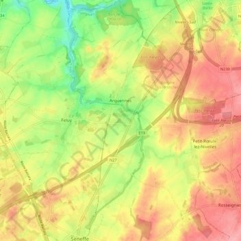
Name: Arquennes topographic map, elevation, terrain.
Location: Arquennes, Seneffe, Zinnik, Henegouwen, Wallonië, 7181, België (50.52868 4.25112 50.59605 4.32067)
Average elevation: 119 m
Minimum elevation: 64 m
Maximum elevation: 162 m
Make a donation
Gear up for your next adventure:
As an Amazon Associate, this site earns from qualifying purchases at no extra cost to you.