Geolocate

Branson topographic map

Click on the map to display elevation.

About this map

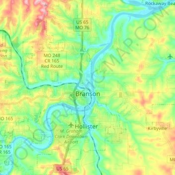
Name: Branson topographic map, elevation, terrain.

Location: Branson, Taney County, Missouri, United States (36.59433 -93.31472 36.70091 -93.21135)

Average elevation: 275 m

Minimum elevation: 210 m

Maximum elevation: 395 m

Other topographic maps

Click on a map to view its topography, its elevation and its terrain.

Ridgedale

United States > Missouri > Taney County

Average elevation: 387 m

McClurg

United States > Missouri > Taney County

Average elevation: 347 m

Rueter

United States > Missouri > Taney County

Average elevation: 345 m

Table Rock

United States > Missouri > Taney County > Branson

Average elevation: 278 m

Mincy

United States > Missouri > Taney County

Average elevation: 278 m

Gear up for your next adventure:

🍽️Titanium Camping Spork - Ultralight and indestructible eating utensil
🧢Beanie Hat - Keep your head warm in cold weather
🥾Trail Running Boots - Durable shoes designed for trail running
🥾Approach Shoes - Shoes designed for climbing approaches and rugged trails
🦶Anti-Blister Balm - Prevents friction and hotspots during long ascents

As an Amazon Associate, this site earns from qualifying purchases at no extra cost to you.