
Thank you for supporting this site ❤️
Make a donation
Make a donation
Gear up for your next adventure:
As an Amazon Associate, this site earns from qualifying purchases at no extra cost to you.
Tignale topographic map
Click on the map to display elevation.
Thank you for supporting this site ❤️
Make a donation
Make a donation
Gear up for your next adventure:
As an Amazon Associate, this site earns from qualifying purchases at no extra cost to you.
Tignale
Tignale befindet sich auf einer Höhe von 555 m über dem Meeresspiegel und liegt etwa 7 km nördlich von Gargnano, 8 km westlich von Malcesine (gegenüber dem See) und rund 10 km südwestlich von Limone sul Garda.
Thank you for supporting this site ❤️
Make a donation
Make a donation
Gear up for your next adventure:
As an Amazon Associate, this site earns from qualifying purchases at no extra cost to you.
About this map
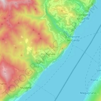
Name: Tignale topographic map, elevation, terrain.
Average elevation: 510 m
Minimum elevation: 56 m
Maximum elevation: 1,606 m
Thank you for supporting this site ❤️
Make a donation
Make a donation
Gear up for your next adventure:
As an Amazon Associate, this site earns from qualifying purchases at no extra cost to you.