Geolocate

Currás topographic map

Click on the map to display elevation.

About this map

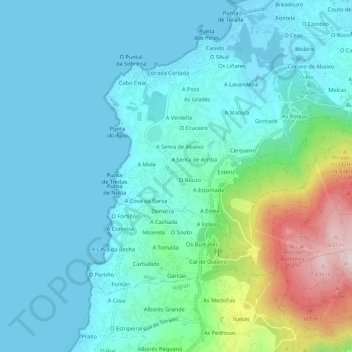
Name: Currás topographic map, elevation, terrain.

Location: Currás, Oia, Vigo, Pontevedra, Galicia, 36390, España (42.15793 -8.82486 42.19793 -8.78486)

Average elevation: 81 m

Minimum elevation: 0 m

Maximum elevation: 425 m

Other topographic maps

Click on a map to view its topography, its elevation and its terrain.

Islas Cíes

España > Galicia > Vigo > Vigo

Average elevation: 3 m

Navia

España > Galicia > Vigo > Vigo

Average elevation: 20 m

Zamáns

España > Galicia > Vigo > Vigo

Average elevation: 397 m

Beade

España > Galicia > Vigo > Vigo

Average elevation: 187 m

Sárdoma

España > Galicia > Vigo > Vigo

Average elevation: 64 m

Illas Cíes

España > Galicia > Vigo > Vigo

Average elevation: 3 m

Coruxo

España > Galicia > Vigo > Vigo

Average elevation: 129 m

Candeán

España > Galicia > Vigo > Vigo

Average elevation: 266 m

Candeán

España > Galicia > Vigo > Vigo

Average elevation: 240 m

Gear up for your next adventure:

🧭GPS Tracker - Track your location in remote areas safely
🧥Insulated Jacket - Keep warm in cold outdoor conditions
🧤Thermal Hiking Gloves - Grip-enhanced gloves for cold-weather altitude trekking
🧳Compression Sacks - Maximize space in your backpack by shrinking gear
🦌Outdoor Trail Camera - Monitor wildlife activity near your favorite spots

As an Amazon Associate, this site earns from qualifying purchases at no extra cost to you.