Geolocate

Colmenar topographic map

Click on the map to display elevation.

About this map

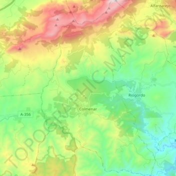
Name: Colmenar topographic map, elevation, terrain.

Location: Colmenar, La Axarquía, Malaga, Andalusia, 29170, Spain (36.85779 -4.37882 36.98279 -4.27680)

Average elevation: 722 m

Minimum elevation: 232 m

Maximum elevation: 1,616 m

Gear up for your next adventure:

🎒Fully Waterproof Backpack - Total protection for photography gear and electronics
🏃Hydration Running Vest - Carry water and maps close to your body for speed
💧Filtered Water Bottle - Safe drinking water on the go
💡Compact LED Flashlight - Powerful and portable flashlight for outdoor use
🔦LED Headlamp - Hands-free lighting for early morning starts or late finishes

As an Amazon Associate, this site earns from qualifying purchases at no extra cost to you.