Geolocate

Lydford topographic map

Click on the map to display elevation.

About this map

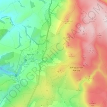
Name: Lydford topographic map, elevation, terrain.

Location: Lydford, West Devon, Devon, England, United Kingdom (50.62851 -4.14264 50.66346 -4.03403)

Average elevation: 327 m

Minimum elevation: 119 m

Maximum elevation: 584 m

Gear up for your next adventure:

🥾Waterproof Trail Shoes - Shoes designed to handle wet terrain
Camping Groundsheet - Protect your tent from moisture and dirt
Family Camping Tent - Spacious tent suitable for family camping trips
🪑Insulated Seat Pad - Protect your seat from cold rocks and wet logs
💧Reusable Water Bottle - Durable water bottles for hydration on trails

As an Amazon Associate, this site earns from qualifying purchases at no extra cost to you.