Geolocate

Escallani topographic map

Click on the map to display elevation.

About this map

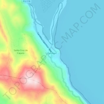
Name: Escallani topographic map, elevation, terrain.

Location: Escallani, Capachica, Puno, Perú (-15.51798 -69.91705 -15.47798 -69.87705)

Average elevation: 3,935 m

Minimum elevation: 3,807 m

Maximum elevation: 4,292 m

Gear up for your next adventure:

🔋Solar Power Bank - Keep your GPS and devices charged during long outdoor trips
🧤Insulated Winter Gloves - Heavy-duty protection for sub-zero Canadian adventures
🧰Survival Kit - Essential gear for emergencies in the wilderness
🧣Merino Neck Gaiter - Protects against wind, sun, and cold at high altitudes
🌡️Emergency Mylar Blankets - Compact thermal protection for unexpected nights outdoors

As an Amazon Associate, this site earns from qualifying purchases at no extra cost to you.