Geolocate

Wanagiri topographic map

Click on the map to display elevation.

About this map

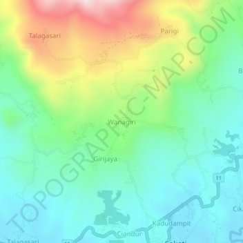
Name: Wanagiri topographic map, elevation, terrain.

Location: Wanagiri, Pandeglang, Banten, Java, 42271, Indonesia (-6.40047 105.96476 -6.36047 106.00476)

Average elevation: 258 m

Minimum elevation: 93 m

Maximum elevation: 629 m

Other topographic maps

Click on a map to view its topography, its elevation and its terrain.

Tanjungjaya

Indonesia > Banten > Pandeglang

Average elevation: 37 m

Tanjungjaya

Indonesia > Banten > Pandeglang

Average elevation: 37 m

Gear up for your next adventure:

💧Filtered Water Bottle - Safe drinking water on the go
🧤Rechargeable Heated Gloves - Extreme warmth for Canadian winter expeditions
🧢Hiking Sun Hat - Wide-brimmed protection for exposed mountain ridges
Camping Essentials - All-in-one gear for a comfortable camping trip
🔦UV Flashlight - Detect minerals or specific insects in the dark

As an Amazon Associate, this site earns from qualifying purchases at no extra cost to you.