Geolocate

Amaro topographic map

Click on the map to display elevation.

About this map

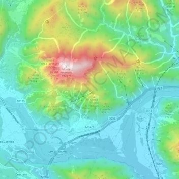
Name: Amaro topographic map, elevation, terrain.

Location: Amaro, Udine, Friuli-Venezia Giulia, Italy (46.36127 13.04985 46.41947 13.16394)

Average elevation: 623 m

Minimum elevation: 231 m

Maximum elevation: 1,872 m

Gear up for your next adventure:

🧶550 Survival Paracord - Versatile utility cord for emergency repairs and rigging
🩹Moleskin Blister Pads - Direct protection for painful foot pressure points
🧥Thermal Fleece Jacket - Versatile insulation for changing mountain temperatures
Camping Groundsheet - Protect your tent from moisture and dirt
💧Reusable Water Bottle - Durable water bottles for hydration on trails

As an Amazon Associate, this site earns from qualifying purchases at no extra cost to you.