Geolocate

Sigor topographic map

Click on the map to display elevation.

About this map

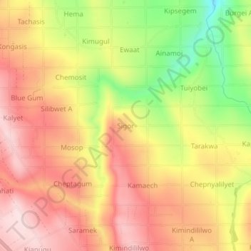
Name: Sigor topographic map, elevation, terrain.

Location: Sigor, Nakuru, Kenya (-0.56740 35.98500 -0.52740 36.02500)

Average elevation: 2,455 m

Minimum elevation: 2,246 m

Maximum elevation: 2,597 m

Gear up for your next adventure:

💧Filtered Water Bottle - Safe drinking water on the go
🥾Light Trekking Boots - Supportive boots for multi-day treks
🧦Outdoor Socks - Durable socks designed for hiking and outdoor sports
🧳Compression Sacks - Maximize space in your backpack by shrinking gear
🧥Softshell Hiking Jacket - The perfect balance of wind protection and breathability

As an Amazon Associate, this site earns from qualifying purchases at no extra cost to you.