
Make a donation
Gear up for your next adventure:
As an Amazon Associate, this site earns from qualifying purchases at no extra cost to you.
Chefchaouen topographic map
Click on the map to display elevation.
Make a donation
Gear up for your next adventure:
As an Amazon Associate, this site earns from qualifying purchases at no extra cost to you.
About this map
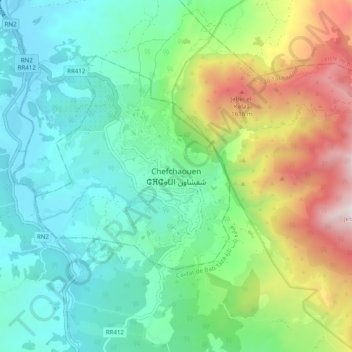
Name: Chefchaouen topographic map, elevation, terrain.
Average elevation: 766 m
Minimum elevation: 267 m
Maximum elevation: 1,984 m
Make a donation
Gear up for your next adventure:
As an Amazon Associate, this site earns from qualifying purchases at no extra cost to you.
Other topographic maps
Click on a map to view its topography, its elevation and its terrain.
Chefchaouen
Chefchaouen ou Chaouen (arabe : شفشاون /ʃəfˈʃɑˑwən/, berbère : ⴰⵛⵛⴰⵡⴻⵏ /ɑʃʃɑwən/) est une ville du nord-ouest du Maroc, bâtie à 600 m d'altitude au pied des monts Kelaa et Meggou, sur la chaîne du Rif. Elle est le chef-lieu de la province homonyme. Sa population est de 42 786 habitants.
Average elevation: 619 m