Geolocate

Goostrey topographic map

Click on the map to display elevation.

About this map

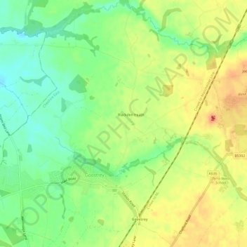
Name: Goostrey topographic map, elevation, terrain.

Location: Goostrey, Cheshire East, England, United Kingdom (53.21817 -2.36380 53.25334 -2.30402)

Average elevation: 67 m

Minimum elevation: 44 m

Maximum elevation: 90 m

Other topographic maps

Click on a map to view its topography, its elevation and its terrain.

Collins Wood

United Kingdom > England > Cheshire East

Average elevation: 91 m

Gear up for your next adventure:

🕶️Polarized Sunglasses - Protect your eyes with durable polarized lenses
🛏️Sleeping Bag - Warm and compact sleeping bags for outdoor camping
🪑Ultralight Camping Stool - Compact seating for rest stops during long hikes
🗺️Topographic Maps - Detailed maps to explore trails, mountains, and wilderness areas
🧳Compression Sacks - Maximize space in your backpack by shrinking gear

As an Amazon Associate, this site earns from qualifying purchases at no extra cost to you.