
Holme St Cuthbert topographic map
Interactive map
Click on the map to display elevation.
About this map
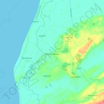
Name: Holme St Cuthbert topographic map, elevation, terrain.
Location: Holme St Cuthbert, Cumberland, Angleterre, Royaume-Uni (54.78022 -3.46813 54.84434 -3.34913)
Average elevation: 13 m
Minimum elevation: 0 m
Maximum elevation: 65 m
Other topographic maps
Click on a map to view its topography, its elevation and its terrain.
Carlisle
Royaume-Uni > Angleterre > Cumberland
Carlisle, Cumberland, Angleterre, Royaume-Uni
Average elevation: 31 m