Geolocate

Målilla topographic map

Click on the map to display elevation.

About this map

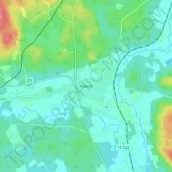
Name: Målilla topographic map, elevation, terrain.

Location: Målilla, Hultsfreds kommun, Kalmar County, 577 74, Sweden (57.36760 15.79217 57.40760 15.83217)

Average elevation: 104 m

Minimum elevation: 88 m

Maximum elevation: 157 m

Other topographic maps

Click on a map to view its topography, its elevation and its terrain.

Kalmar kommun

Sweden > Kalmar County

Average elevation: 28 m

Mönsterås kommun

Sweden > Kalmar County

Average elevation: 26 m

Gear up for your next adventure:

🥾Approach Shoes - Shoes designed for climbing approaches and rugged trails
🧤Rechargeable Heated Gloves - Extreme warmth for Canadian winter expeditions
🧥Waterproof Jacket - Lightweight rain jackets for hiking and outdoor activities
🥾Trail Running Shoes - Lightweight and durable shoes for trail running
🧥Waterproof Pants - Keep dry during rainy hiking conditions

As an Amazon Associate, this site earns from qualifying purchases at no extra cost to you.