Geolocate

Laurel topographic map

Click on the map to display elevation.

About this map

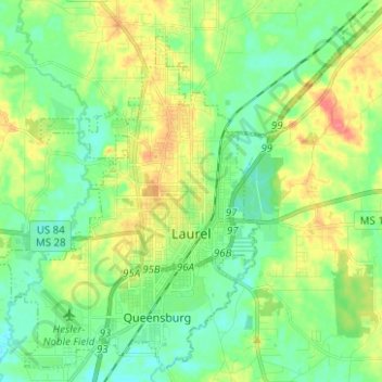
Name: Laurel topographic map, elevation, terrain.

Location: Laurel, Jones County, Mississippi, 39440, United States (31.65616 -89.19372 31.75599 -89.06907)

Average elevation: 77 m

Minimum elevation: 57 m

Maximum elevation: 114 m

Other topographic maps

Click on a map to view its topography, its elevation and its terrain.

Myrick

United States > Mississippi > Jones County

Average elevation: 75 m

Sand Hill

United States > Mississippi > Jones County

Average elevation: 79 m

Lanham

United States > Mississippi > Jones County

Average elevation: 63 m

Gear up for your next adventure:

👟Leg Gaiters - Keep debris, mud, and snow out of your boots
🧦Hiking Liner Socks - Thin base layer to prevent friction and blisters
🥾Approach Shoes - Shoes designed for climbing approaches and rugged trails
🦯Trekking Poles - Reduced impact on joints for steep topographic climbs
🧥Packable Rain Jacket - Breathable waterproof layer for unpredictable weather

As an Amazon Associate, this site earns from qualifying purchases at no extra cost to you.