Geolocate

Bulak topographic map

Click on the map to display elevation.

About this map

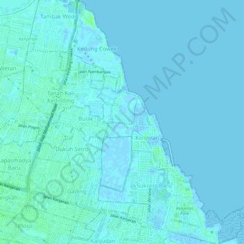
Name: Bulak topographic map, elevation, terrain.

Location: Bulak, Surabaya, East Java, Java, Indonesia (-7.25580 112.77049 -7.20823 112.81103)

Average elevation: 2 m

Minimum elevation: -7 m

Maximum elevation: 8 m

Other topographic maps

Click on a map to view its topography, its elevation and its terrain.

Asemrowo

Indonesia > East Java > Surabaya

Average elevation: 4 m

Taman Prestasi

Indonesia > East Java > Surabaya > Ketabang

Average elevation: 6 m

Dukuh Pakis

Indonesia > East Java > Surabaya

Average elevation: 9 m

Dukuh Pakis

Indonesia > East Java > Surabaya

Average elevation: 15 m

Gear up for your next adventure:

🧤Thermal Hiking Gloves - Grip-enhanced gloves for cold-weather altitude trekking
🥾Mountain Hiking Boots - High-traction boots for rocky terrain
🐕Hiking Dog Pack - Let your canine companion carry their own water and food
🏕️Camping Hammock - Integrated protection for sleeping between trees
🥾Mountain Trail Shoes - High-traction shoes for mountain trails

As an Amazon Associate, this site earns from qualifying purchases at no extra cost to you.