
Make a donation
Gear up for your next adventure:
As an Amazon Associate, this site earns from qualifying purchases at no extra cost to you.
Fillmore topographic map
Click on the map to display elevation.
Make a donation
Gear up for your next adventure:
As an Amazon Associate, this site earns from qualifying purchases at no extra cost to you.
About this map
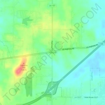
Name: Fillmore topographic map, elevation, terrain.
Location: Fillmore, Bossier Parish, Louisiana, 71067, United States (32.54279 -93.53498 32.58279 -93.49498)
Average elevation: 81 m
Minimum elevation: 59 m
Maximum elevation: 127 m
Make a donation
Gear up for your next adventure:
As an Amazon Associate, this site earns from qualifying purchases at no extra cost to you.
Other topographic maps
Click on a map to view its topography, its elevation and its terrain.
Bossier City
United States > Louisiana > Bossier Parish
Bossier City is located at 32°31′4″N 93°41′29″W / 32.51778°N 93.69139°W / 32.51778; -93.69139 (32.517651, −93.691397) within the Ark-La-Tex and has an elevation of 174 feet (53.0 m) above sea level. The city lies primarily on the banks of the Red River, and has a largely flat topography…
Average elevation: 55 m