Geolocate

Saint-Prex topographic map

Click on the map to display elevation.

About this map

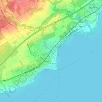
Name: Saint-Prex topographic map, elevation, terrain.

Location: Saint-Prex, District de Morges, Vaud, 1162, Switzerland (46.47070 6.42796 46.49977 6.47975)

Average elevation: 398 m

Minimum elevation: 369 m

Maximum elevation: 476 m

Other topographic maps

Click on a map to view its topography, its elevation and its terrain.

Morges

Switzerland > Vaud > District de Morges > Morges > Morges

Average elevation: 418 m

Mont Tendre

Switzerland > Vaud > District de Morges > Montricher

Average elevation: 1,508 m

Gear up for your next adventure:

🧥Insulated Jacket - Keep warm in cold outdoor conditions
Backpacking Tent - Lightweight tent for long-distance hiking trips
🧊Portable Cooler - Keep food and drinks cold during outdoor adventures
🧥Ultralight Puffy Jacket - Maximum warmth that packs down to the size of an orange
🧢Outdoor Cap - Protective cap for sun and rain during hikes

As an Amazon Associate, this site earns from qualifying purchases at no extra cost to you.