
Al-Hofuf topographic map
Interactive map
Click on the map to display elevation.
About this map
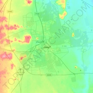
Name: Al-Hofuf topographic map, elevation, terrain.
Average elevation: 161 m
Minimum elevation: 115 m
Maximum elevation: 292 m
Other topographic maps
Click on a map to view its topography, its elevation and its terrain.
Jubail Industrial City Reservoir
Saudi-Arabien > Provinz asch-Scharqiyya
Jubail Industrial City Reservoir, محافظة الجبيل, Provinz asch-Scharqiyya, Saudi-Arabien
Average elevation: 3 m
al-Chubar
Saudi-Arabien > Provinz asch-Scharqiyya
al-Chubar, محافظة الخبر, Provinz asch-Scharqiyya, 34436, Saudi-Arabien
Average elevation: 8 m
al-Dschubail
Saudi-Arabien > Provinz asch-Scharqiyya
al-Dschubail, محافظة الجبيل, Provinz asch-Scharqiyya, 11102, Saudi-Arabien
Average elevation: 5 m