Geolocate

Bardhaman topographic map

Click on the map to display elevation.

Bardhaman

The region has an average elevation of 40 metres (131 ft). The city is situated 1100 km from New Delhi and a little less than 100 km north-west of Kolkata on the Grand Trunk Road (National Highway 19) and Eastern Railway. The chief rivers are the Damodar and the Banka.

About this map

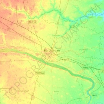
Name: Bardhaman topographic map, elevation, terrain.

Location: Bardhaman, Burdwan - I, Paschim Bardhaman, West Bengal, 713102, India (23.08957 87.70818 23.40957 88.02818)

Average elevation: 30 m

Minimum elevation: 14 m

Maximum elevation: 45 m

Gear up for your next adventure:

💡Portable Camping Lamp - Rechargeable lamp for campsite lighting
🔭Outdoor Binoculars - Lightweight binoculars for birdwatching and hiking
🧥Waterproof Pants - Keep dry during rainy hiking conditions
🧣Evaporative Cooling Towel - Beat the heat during intense summer climbs
🧥Softshell Jacket - Windproof and breathable jacket for hiking

As an Amazon Associate, this site earns from qualifying purchases at no extra cost to you.