Geolocate

Blythe topographic map

Click on the map to display elevation.

About this map

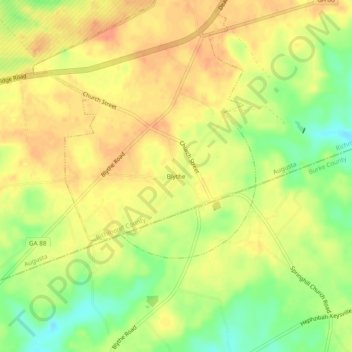
Name: Blythe topographic map, elevation, terrain.

Location: Blythe, Richmond County, Georgia, 30805, United States (33.27264 -82.22151 33.31264 -82.18151)

Average elevation: 134 m

Minimum elevation: 108 m

Maximum elevation: 150 m

Gear up for your next adventure:

🧊Portable Cooler - Keep food and drinks cold during outdoor adventures
🔭Compact Monocular - One-handed bird watching and trail spotting
💧Collapsible Water Bottle - Space-saving water bottle for outdoor activities
🥾Durable Hiking Shoes - Long-lasting shoes for frequent hiking
🔭Compact Binoculars - Lightweight optics for scouting trails and wildlife

As an Amazon Associate, this site earns from qualifying purchases at no extra cost to you.